
Singlehanded
sailing can be tough… Doros discovered this relaxing steering position. You
only have to nudge the wheel every 60 seconds or so. Staying awake is the real
trick.
Anyway,
after a couple of days at Cayo Largo I leave, heading West. The marina is tucked
in among the mangroves and is quite tricky to navigate away from.


Hint, don’t
head for the red and green marks directly, good job the water is clear.

So, you
don’t go over the white bits either – navigation among reefs is quite tricky
and difficult, I am slowly gaining experience but the trouble is when the
weather is quiet you can’t see the reefline. Looking at the sea with a friendly
sun behind you helps but in my opinion there are 40 shades oif green and
picking the one that is sand, (bright green) or turtle grass (olive short of
dark – or maybe that is rock) and the coral which can be sand coloured or
yellower is difficult. I am not too good at distinguishing between the bits. And if the sun
doesn’t shine right you can’t make it out anyway. There are some harrowing bits
of navigation in the last 150 miles to Havana on the North West coast. The
Southwest coasts are not too bad.
I travel
23nm from Cayo Largo to an uninhabited Cayo Rosario – a gap between the south
side and the north side of the cays, I anchor in peace and leave at first light
(7.00 am) to travel 37 miles to the SE corner of the large Ilha de Juventid –
the Punta Del Este

Diagram from Nigel Calders book "Cuba, a cruising guide"
The
anchorage there is remote too and doesn’t look like much, in practice the reef
keeps the sea right down and I have a peaceful night. The whole south side of
Cuba has been easy anchoring actually – even when the wind is blowing right
into what looks like an open roadstead the underwater topology keeps the waves
down and you can anchor in 3m in complete peace. Even with 15-20 knots which we
get often in the late afternoon. By teatime the wind goes to sleep and does not
come up until mid morning. I rise at first light and strike out along the
bottom of the Ilha – there are no suitable stops for 41 miles until a marginal
anchorage at Caleta Puerto Frances. I have sailed most of the last few legs to
conserve fuel as I expect to motor most of the North coast if prevailing East
or NorthEast winds establish themselves. (in the end I get Jerry cans filled at
Marina Sigueana and the boat topped up just around the corner at Les Morres). I
share Caleta Puerto Frances with a Canadian couple who I chat to at the next
port (Mary and Dave Rose in S/V Wandering Rose – nice boat name!) and also the
boat below.

The next
port I call it is Marina Sigueana – I am hoping to get fuel. The marina is just
up a river and has a full military base (a couple of older Guarda Frontera and
half a dozen young pups who do weightlifting and grasscutting – I suspect they
are on their national service) The marina is quiet. In fact when I try to leave
the Guarda gets me to wait for the dockmaster to arrive – who makes out my
paperwork - 13 CUC for the privilege of
anchoring and fuel for my jerrycans at one CUC/Litre. The marina has suffered
silting since a hurricane blew sand up the river and has only 1.5m now. A pity
although there is nothing there – the marina serves some motorboats from the
nearby hotel that take guests out for a ride or a dive. The nearby hotel has no
Wifi – I discover this after a 1km hike up the road. It has a pool and a beach.
Maybe that is all you need (well… cheap rum too…)

Military
bases seem to be always painted blue (though often so are marina buildings…)
After fueling up I head North West a bit as the
only stopping place is the extreme West end of the Cayo de Indigios – being
singlehanded with no autopilot I don’t fancy a 80 mile direct passage and split
it into 44 to the Cayo and then a mere 68 to La Gorda. I only get 12-13 hours
of daylight and sailing at night is best avoided with no autopilot
Diagram from Nigel Calders book "Cuba, a cruising guide"
I tuck in
near the anchor symbol and again have a quiet night. The reefs could be seen as
white surf and I could hear them all night (just about). And then it is on to Marie La Gorda – a big dive centre. Many self catering chalets and several
restaurants. Also the area is a national park and frowns on anchoring – I come
in, start to anchor and a diveboat toots its horn and directs me to a buoy. The
only buoy near the dock, there are 30 diving buoys dotted along the coast and I
had seen a couple of French boats on these about a mile away from the bar.
Probably trying to avoid the 13 CUCs/night on the buoys.
I caught my
first Caribbean green flash here. I have seen these in Donegal across
Tranarossan flats and also a partial one crossing the Norwegian Sea between
Bergen and the Shetlands. The Green Flash occurs when the air is still and
clear and there are no clouds or much water in the atmosphere near sealevel. It
requires NO pollution!
Unfortunately
it only lasts about a quarter of a second and I missed photographing it. Video
is the answer – next time.

Shadowmere
is off to the right in this picture – with its anchor and its cockpit lights
on.

They have
four of these dive boats and massive compressors, they are operating two boats
so there are plenty of divers about. Note the do not anchor sign, not easy to
see from seaward!

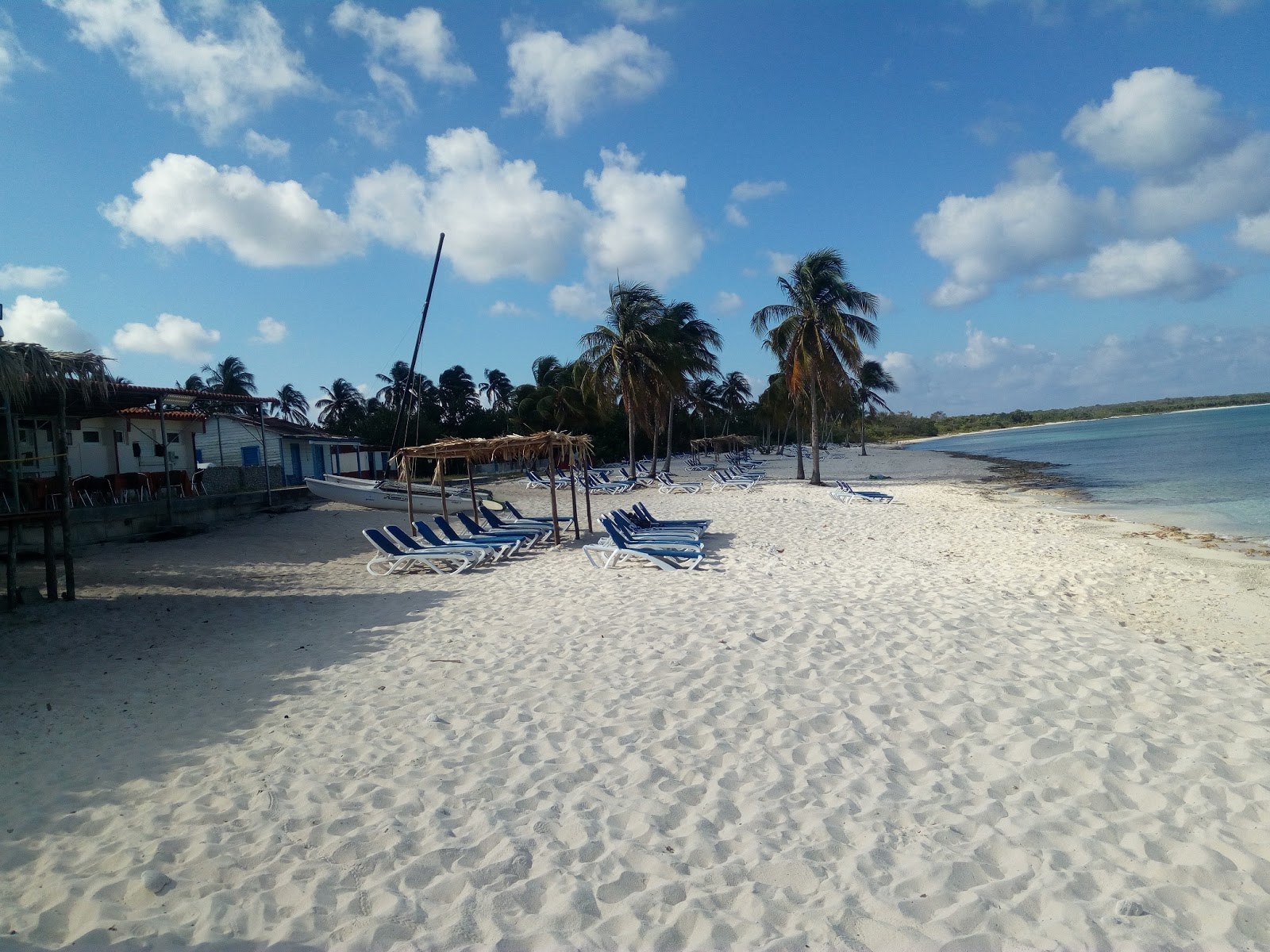
Life is a
beach (in between dives I assume)
There is
also tennis, fooba, table tenis and an outdoor chess set (pieces about 2 feet
high)

Shade is good...

And a view
from seaward, do you like the water colour?
I nearly
talk myself into a 30m dive along the coast but reckon that solo diving from a
boat with no-one on board is asking for trouble. I must be learning prudence as
I get older. There are bold divers and there are old divers but there are no bold old divers... A pity as I have yet to dive a coral wall/drop off. I leave here at 10am – again they try to get
the harbormaster to visit me but in the end the Guarda takes 25 CUC from me and
clears me out. They have no fuel but tell me that Les Morres around the corner
has. It had better…
The
corner, like any corner cuts up roughish but not too bad – 25 knots


Somewhat
windswept mangroves. Mexico is about 105 miles from here by the way. See next
winter for more about that!
Les Morres
has a concrete dock but it is blowing old boots right into it when I arrive so
I anchor and motor alongside in the morning to clear in and get fuel. The place
deserves to do well but in reality there is nothing there – a marina,
restaurant/café/bar, a “shop” and the Guarda – and a good fuel pump. It is in a vital location for boats going either
way along the coast and is good to clear in from Mexico – unfortunately
clearing in from abroad needs a lot more staff than just the guarda
frontera - it needs immigration,
customs, drugs, military intelligence, department of agriculture and a medical
doctor. Seven uniforms and a dog. Six of these (and the dog) have to come from
afar by car and that takes time so I think Les Morres has fallen off the international
clearing in list. You can get your local despacho stamped though, which is all
I need.

The boat in
front is Ariel and is being helmed singlehanded by Arnolf. His blog at www.sy-ariel.de is interesting reading and we keep
pace the whole way to Havana where we have a few beers together. In fact he is
heading up the East Coast of the states towards Newfoundland, not unlike my own
plans to go to Nova Scotia (because it's there) although his mast height means
he must go outside the ICW.
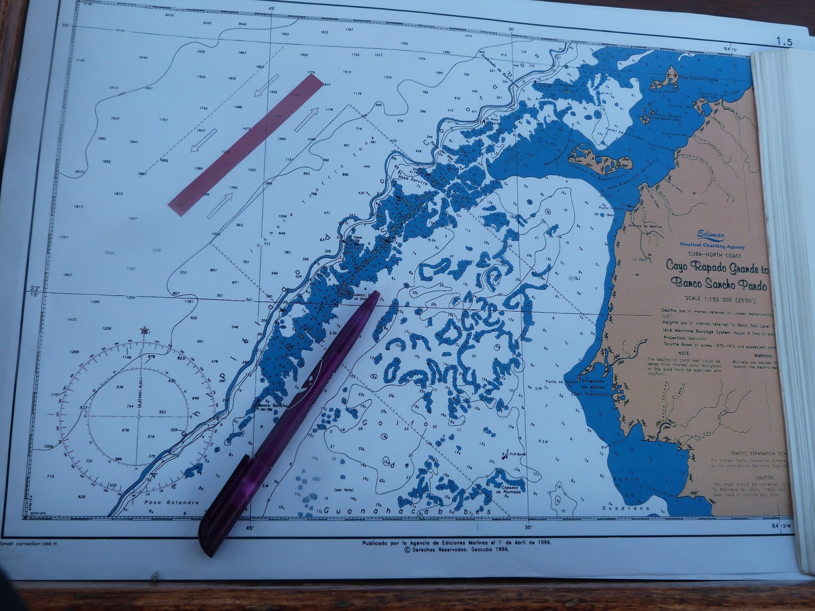
The next
stops are tricky – I decide to go inside the reef. This means very shallow
waters ( I manage 2.2m the next day) with largely suspect charts – I have three
sources Garmin and Navionics electronic charts and also paper Cuban charts. What
to do if they don’t agree and there are three possibilities? The Cuban charts
are surveyed in 1995 and were done accurately (mainly – apparently). But Coral
grows, it is impossible to survey every rock and there may be outliers sitting
in a supposedly clear shallow area. Eyeballs and depth sounders are vital here.
A pity I only have two (of each)

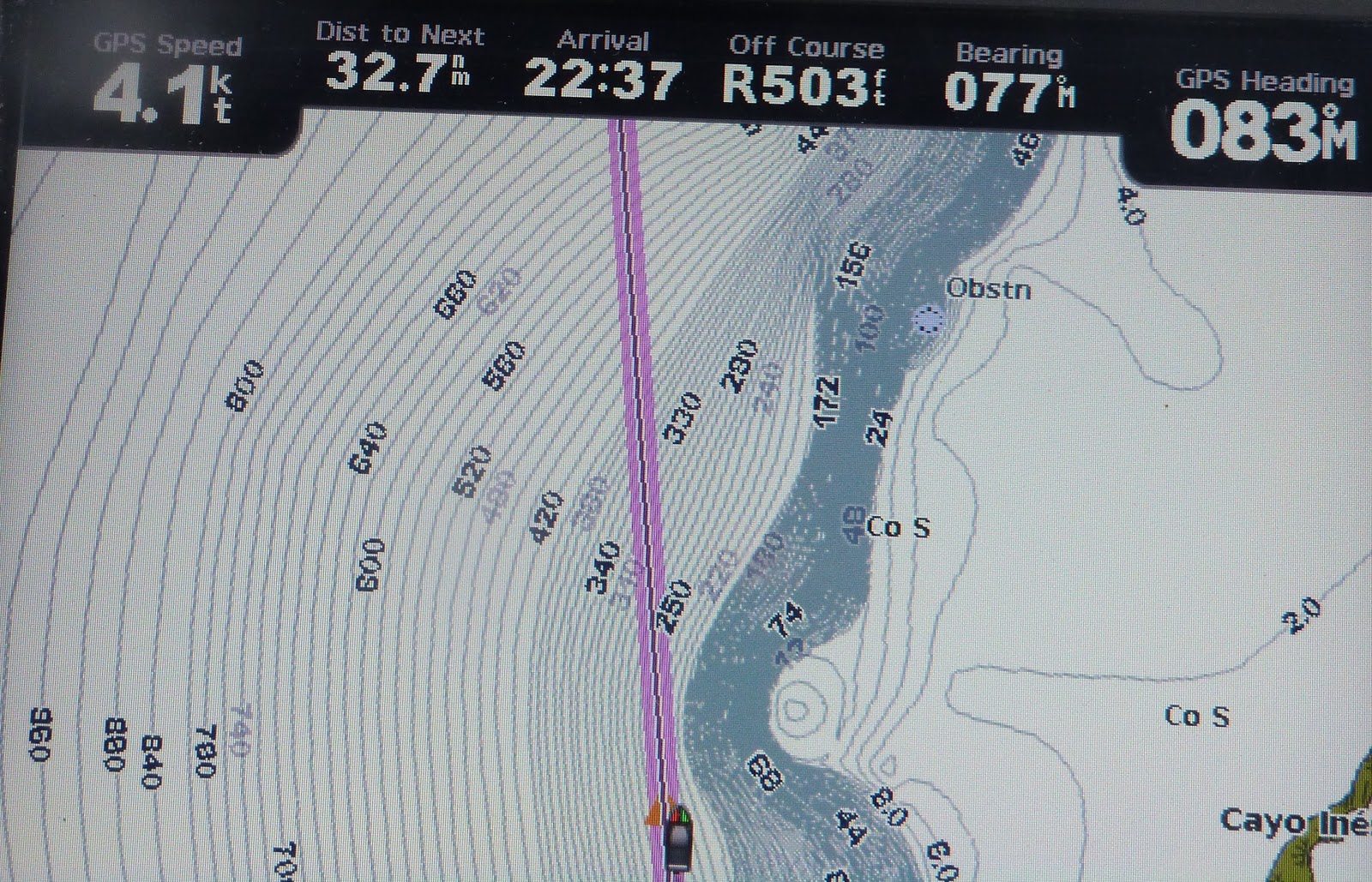
So,
the chart plotter shows quite a busy underwater picture

Above water
the sun is not helping and the lack of wind hides the rocks. God help anyone
going here before chart plotters.
I travel up the pen to anchor in Cayo Buenavista
– the island sticking out in the top right.

Just
mangroves, I creep into 3m and anchor

Sun
helps a bit the next day

And into
Cayo Jutias – there is a resort on the North of this island but I just anchor
in the South – you can’t easily motor around. (you probably could very slowly –
preferably with “local” knowledge -
that’s where you have been around long enough to see where the other boats run aground)
Next day I backtrack a couple of miles to find a
gap in the reef. The Garmin chartplotter lets me down here – first it just
marks the whole reef area in red and says danger area. Then it puts a green
mark in the wrong place – Navionics and paper charts show the green mark on top
of a shallow bit My route passes to the left of the actual green mark which is near the rock symbol

Bouyage is
different to Europe (Iala B) so you should put Green on the left coming in from
seawards (North). The adage is “Red Right Returning” which spoils my personal
European mnemonic of “Is there even any tomato soup cans left” Here I have to
put the green well on my right as I leave. I go slowly though anyway! (track had
7m all the way) Phew.
Been a
while since I photographed a lighthouse – Jutias has one, and very pretty it is
too. Mind you all lighthouses in Cuba are owned by the military so if I
disappear you’ll know why…

Navigating
outside the reef is easier – you can see the shallow bits. I find I get weird
currents out in the deep, I experiment with getting near the “slope” and away
from the slope but come to no conclusions as to which reduces the current – it
just seems to come and go.

You can see
the plateau inside the reef. Also Cuba has some nice mountains.
The fishing
chart view from the Garmin plotter slows the slope. The depths are in Metres.
The contours are interpolated by software and I don’t trust algorithms (unless
I write them myself).

Wind
goes to sleep at night. I get into Bahai de Honda as dusk approaches – this is
a narrow finger mouthed bay of which there are 3 in the last 50 miles
approaching Havana but the other two are off limits . The reef goes right up to the beach along the coast for miles so it
is plain sailing (sic).

The Guarda
building and dock are derelict but I anchor off it as per the pilot book
instructions. I had also radioed in as I approached the bay but had no answer –
this suits as I want away early in the morning without all the clear in and
clear out hassle that all manned ports and marinas require.
The entrance is narrow but well marked, the
Cubans seem to like leaving shipwrecks as marks
-

On route
for Havana I am minded of the Hemingway book “The old man and the Sea”
He wrote "Every day is a new day"

Straw hats
are de rigour.
And then into Hemmingway Marina – a large place,
built in the 1950s that has had many facilities – hotels (2) restaurants, cafes,
swimming pools, tennis courts etc., I am just happy tp see good toilets and showers!
And a wee café/bar that is air-conditioned with Wifi – in fact the Wifi reaches
the boat which is a luxury! I still need the vouchers though and the local café
sells these for 1.50 Cuc/hour


The
customs dock is just along there - I
pull in just in front of Ariel, A host of dockmasters appear and take my ropes.
Nice! The layout is several long (0.5 mile) canals with “intercanal” land where
the facilities go. And a hundred private residences too

There we
are, safe and sound.


You can
swim in the canals, but the next intercanal landmass has a hotel with a pool.

And so to
Havana and the family holiday – Shirley arrives in a couple of days and the
kids and Amy next week. I have to renew my visa and clean the boat! Renewing
the visa takes 5 hours (all day really as I am knackered by the time I have it
done) It requires visiting the main immigration office in Havana and also needs
special stamps purchased at a bank (but not every bank). I cycle in to town, which given
the extreme heat may not have been sensible. Still. I succeed, when I return I
get invited onto Ariel for a beer and we discuss the merits of going straight
to Marathon in Florida instead of Keywest. It is only 20 miles further but has
easier customs and is further up the ICW. My visa runs out on 2nd
May so I hope to be leaving shortly after Shirley goes on the 28th
April. Before them I will upload some holiday snaps of Cuba.